Zombies - you've seen them in the movies, mindlessly marching on, implacable, unthinking, terrifying, intent on their destination with no thought of what's around them.
The Undead. Much like many of the new boaters heading south on the ICW in fact - unthinking and intent on getting south with no thought of what's around them.
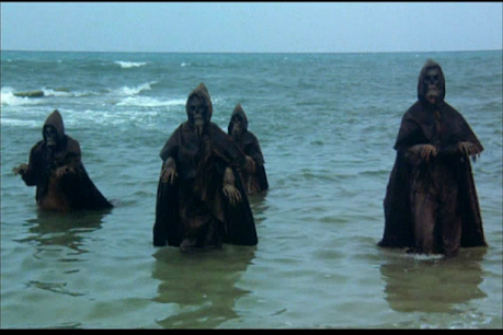
It's said that one of the best reasons for learning to sail is that at the end of the world, you're safe on a sailboat, because zombies cannot swim. I don't know the truth of that, but I do know this - zombies can sail. I've observed them many times on the Intracoastal Waterway, following their predetermined path with no thought, no eyes, for anything but that blue line on the screen they are staring at.
I saw two of them today in fact, motoring one after the other down the ICW in southern Georgia. There they were, at least 75 yards out of the charted channel, following the path that the 423 Zombies are mandated to follow, no matter where it leads, Aids to Navigation be damned!
I am speaking of course of those boaters who have joined the Cult of Sherer, the AquaMaps people, the 423 Zombies, who believe that their leader, Bob Sherer, can do no wrong.
Now in this case, it might also just be that these followers, these sailors, being Canadian, were reaching out desperately for whatever assistance they could find on their trek south to the sun that long ago deserted the Great White North.
Let's face it, it's a long way from the Great Lakes to south Florida.

I'm told that in a past life, their leader was a corporate executive, so I suppose this picture could easily be one from before he became the leader of the 423 Zombies. Living life as a corporate executive has been known to do strange things to people. Ask any wokester!
By now, most of you have figured out that I'm trolling the sailors who travel the ICW using what have become known as Bob Tracks, a creation of GPX routes by Waterway Guide cruising editor Robert Sherer.
Essentially, what Bob has done is take a recording of his route along the ICW and transferred it online, making it available for download to his social media group. Once these folks have downloaded the tracks, they can transfer them to their AquaMaps app on their phone or tablet. They then simply follow the charted route.
Like zombies, never wavering from it.
Now don't get me wrong. For someone entirely new to the ICW, this has some advantages. They don't have to bother learning how to navigate for one thing. I mean, really, who needs to deal with issues of set and drift, plotting, getting a fix, or how to use dividers or understand what all those tiny letters on a chart actually mean?
It's SO much easier to just follow the blue line laid out in front of you on your tablet.
For those of us with a lot of experience on the ICW - I'm now somewhere around 50 transits - this can be entertaining as you watch a line of boaters follow a path that sometimes takes the long way around, or that avoids an "obstruction", or shoaling, that isn't really an issue.
The other day, I watched one boater directly in front of me go well outside of the channel at the Carolina Inlet to avoid what he was told was a shoal there. I continued on straight, knowing that the "shoal" was at least 8 feet deep at MLW and there was no need to change course.
Here's the chart for this area, with Bob's Tracks in blue.
Here's the chart for this area, with Bob's Tracks in blue.

Is anyone hurt by diverting as this boater did? No, and if you feel better or safer by mindlessly following someone else's track in this way, go for it.
But as sure as God made puppies, there will come a day when two boaters going in opposite directions are going to meet at that diversion and someone is going to have to do some actual thinking about how and where to navigate their boat to avoid a collision or going aground.
And this isn't a joke. The outline to using the Bob Tracks discusses this exact scenario, advising boaters that they must pass port to port, that the regulations REQUIRE them to do so. The problem is, if you're so clueless about navigation that you have to use someone else's tracks to get where you're going, you're very unlikely to know the rules of the road.
So if that's all there is, why am I bitching about this?
Well, today I watched two sailboats coming down the ICW approaching the Kings Bay Naval Base in southern Georgia. That's the base where they keep nuclear submarines, in case you didn't know. The naval patrol boats that guard the base are extremely watchful, and if you come anywhere near the base - as in within 500 feet, they come out to greet you with a sailor standing on the bow manning a deck mounted 50 calibre machine gun. They are not kidding around. When a sub is moving out, all traffic on Cumberland Sound is stopped by the USCG. You're ordered to move to the far side of the channel and if you refuse, as one sport fisherman did years ago, you're pulled over and taken off your boat in handcuffs.
I was holding my position, waiting for two boaters from my Sail to the Sun ICW Rally to catch up. One had been having fuel problems and was moving very slowly with another of the group covering him. The two zombies were ahead of my two. At one point, the zombies moved out of the channel, leaving two red channel marks to port to avoid a shoal, as noted by the red arrows.
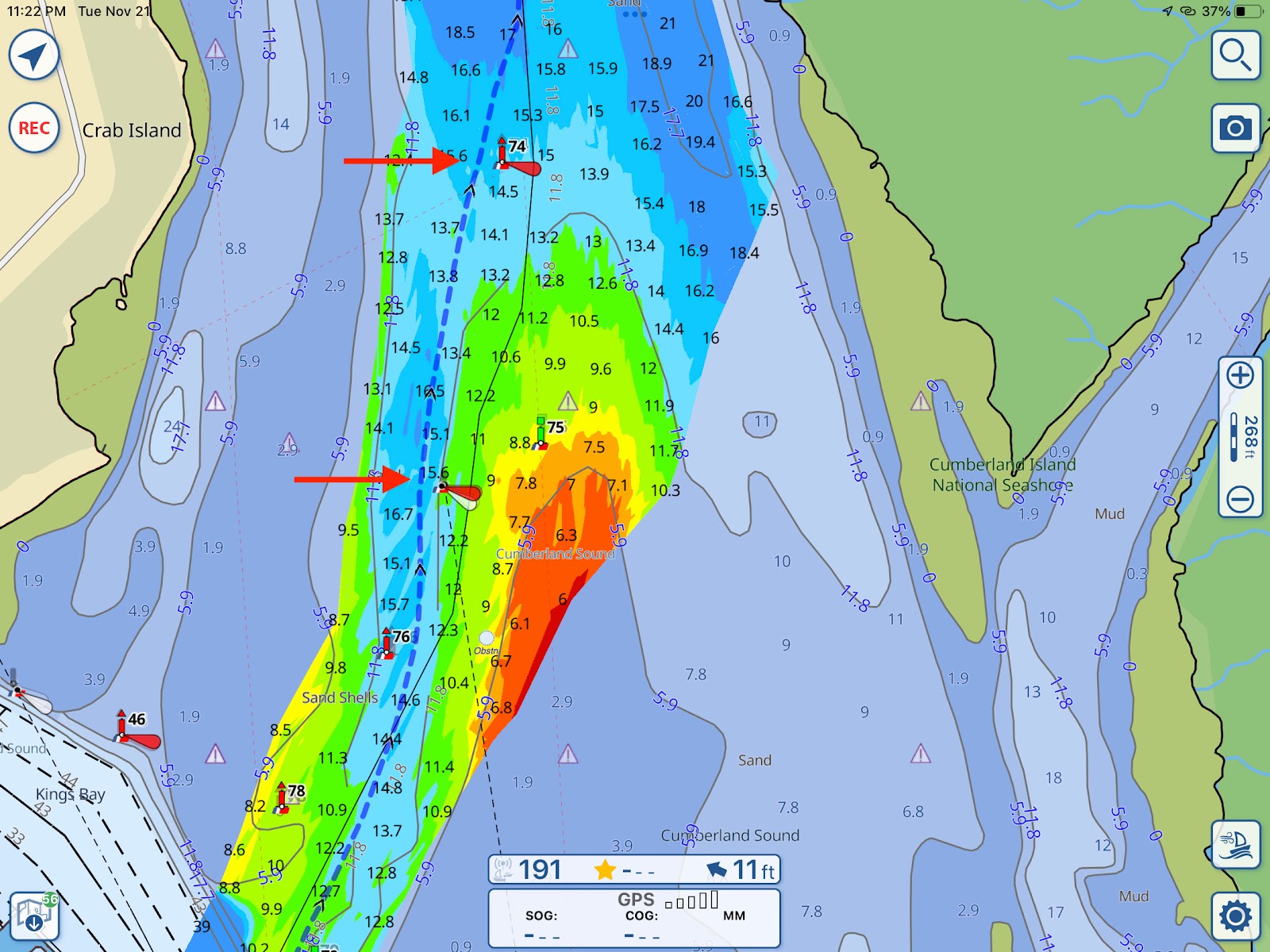
These boaters didn't know they were moving into a restricted area. But, they would not have been in that restricted area had they not been following Bob's Tracks. And fortunately, the patrol boat was at the far end of his patrol area when this happened.
Notice, there IS a shoal there, but by staying to center channel, as noted by the green and red markers, you're going to be in over 12 feet of water at MLW. We were an hour off high tide. I was sitting just outside the channel in 18 - 22 feet of water.
So I hailed the zombies as a courtesy to let them know they were out of the channel. One of them called back, Zombie-like, and said, I kid you not: "There's a shoal there and I'm the captain of my own boat." Well, I guess he told me, didn't he?
My response isn't worth repeating verbatim here, but it did involve telling this boater that a captain would have used his intelligence and stayed in the channel since it presented no hazards.
What hazards? You can generally be sure that the marked channel contains no hidden hazards, no sunken boats or debris from a hurricane that hasn't been removed. Outside of the channel, you have no guarantees. I have hit underwater debris when moving outside of a channel, fortunately not doing any damage. I've seen boats damaged in this way. My point is, that garbage is there and presents a hazard. Why push your luck by venturing outside of a marked channel when you don't have to?
Part of this attitude about honouring navigational marks comes from learning to sail, and then becoming a charter captain, in Lake Huron's Georgian Bay and North Channel. In those waters, the bottom is not mud, it's granite, as in "rock hard granite". Make a mistake there and you sink your boat, so I tend to honour navigational marks with a religious fervour.
The 423 Zombies, and I've seen this in person, follow their leader's tracks exactly. Given that the actual serious problem areas on the ICW number less than a dozen, and then only at low tide, with a very small bit of planning, that's not necessary. You can get by simply by approaching these problem areas at mid to high tide.
That's what I do. Rather than risk a grounding, I plan my approach to places like Little Mud River, Jekyll Harbor, Brown's Inlet and others so that I pass through with lots of extra water under my keel. That gives me a margin for error just in case I fail to pay close enough attention and drift off the deepest water.
An example will be useful here. The Sail to the Sun ICW Rally went through Little Mud River two days ago. Little Mud shoals to about 4 feet at MLW, making it impassable for most boaters.
The day previous to getting there, we ended our day five miles and an hour early, anchoring in Crescent River beside Creighton Island. Got the afternoon off to relax, soak up some sun, do some reading.
We started the next day a bit later than usual, so on arriving at Little Mud River 90 minutes after low tide, we had 2.5 feet of extra water underneath us and a rising tide. Our deepest draft vessel was five feet, leaving a good margin of safety.
This tactic also brought us to Jekyll Creek, another challenging area, later that same day at just after high tide, with 8 feet of extra water to safely get to the marina.
Planning is the key to comfortably and safely transiting the ICW, or any body of water. Take all the factors into consideration, and then time your passages to avoid problems, even if it means knocking off early the day previous. Running into the sunset until you can barely see before stopping is for delivery captains who know what they're doing, and fools who think they know.
I've been a delivery captain and run late when I had to, but I ain't no fool. And yes, I do take a look at Bob's Tracks, just as I check the online NOAA charts and other information in difficult areas to be sure I've not missed anything. I just don't follow the tracks religiously. They simply aren't that vital for all but the aforementioned problem areas on the ICW, and then, largely for newbies to the ICW.
Here's another thing I've noticed, and I'm quite surprised to see it.
My B&G chartplotter is in for repairs, so I've been using AquaMaps (without the tracks downloaded) in its place. I usually only use AquaMaps for planning purposes, as I like a properly designed chartplotter at the helm.
Why you ask? A tablet or phone will shut itself off if it gets overheated in the sun and won't restart until it has cooled down.
Imagine that happening while you're in the middle of navigating through a difficult area - suddenly, no charts! I've had my phone shut down while using it at the helm for music, leaving me having to sing to entertain myself. If you've heard me sing, you know that's not a good thing!
Anyhow, AquaMaps is quite the nice program, and I'm impressed with its features, including the ability to download hydrographic charts of the bottom so that you can be aware of shoaling and make plans for it.
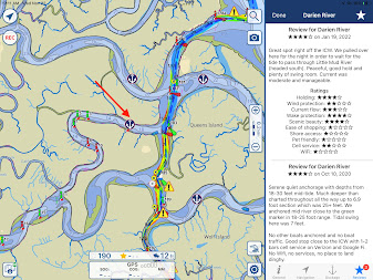
Another feature are the Waterway Guide anchorages that can be downloaded to the charts, allowing you to find a decent anchorage at the end of the day. But - and this is a problem - I've noticed that several of the anchorages shown are in marked channels. If you've been boating for any length of time, you know you aren't supposed to anchor in a marked channel, such as the one in this photo shown by the arrow.
Anyhow, AquaMaps is quite the nice program, and I'm impressed with its features, including the ability to download hydrographic charts of the bottom so that you can be aware of shoaling and make plans for it.
Another feature are the Waterway Guide anchorages that can be downloaded to the charts, allowing you to find a decent anchorage at the end of the day. But - and this is a problem - I've noticed that several of the anchorages shown are in marked channels. If you've been boating for any length of time, you know you aren't supposed to anchor in a marked channel, such as the one in this photo shown by the arrow.
What these "reviewers", whose names I've redacted, seem to be unaware of is that at the end of this river is a fleet of shrimpers out of Darien, GA, who use this river regularly, day and night. And clearly, whoever chose to put this anchorage up isn't paying attention to the details either.
This is not a proper anchorage, it's a marked channel in which anchoring is not permitted.
And it's not the only one marked like this, so be aware.
This is not a proper anchorage, it's a marked channel in which anchoring is not permitted.
And it's not the only one marked like this, so be aware.
Do I use Bob's Tracks? As I admitted above, yes, I do. I review them as I do all the available information in order to plan my day's passage, because smart boaters use every little piece of information they can get. I just don't get all Zombie like over them, and neither should you, and I don't refer to them at the helm because my planning doesn't require that.
If you don't know or haven't learned how to navigate, contact your local Power Squadron, Coast Guard or sailing schoool and learn how. It's not all that difficult, and it gives you an incredible burst of confidence to know that, should your chartplotter ever fail while underway (it's happened three times to me!), you're fully capable of finding your way to your destination safely without it.
If you don't know or haven't learned how to navigate, contact your local Power Squadron, Coast Guard or sailing schoool and learn how. It's not all that difficult, and it gives you an incredible burst of confidence to know that, should your chartplotter ever fail while underway (it's happened three times to me!), you're fully capable of finding your way to your destination safely without it.
(Full disclosure - I was a cruising editor for over ten years for Waterway Guides. I have never been a zombie and the only dead flesh I eat is a medium rare strip loin!)